Digital business transformation examples: 10 Real-World Case Studies
Feb 10, 2026 in Listicle: Examples
Discover digital business transformation examples and how AI, data, and strategy fuel growth with practical, actionable insights.
Not a member? Sign up now
Imagine being able to make better decisions about where to live, where to establish a new business, or how to understand the changing dynamics of urban neighborhoods. Learn more about how we're doing this using AI in this blogpost.
Paulo Maia on Oct 31, 2024
Imagine being able to make better decisions about where to live, where to establish a new business, or how to understand the changing dynamics of urban neighborhoods. Access to detailed, up-to-date information about city environments allows us to answer these questions with greater confidence, but the challenge lies in accessing and analyzing the right data.
While tools like OpenStreetMap help us locate basic amenities, their reliance on crowdsourcing often results in outdated or incomplete information, making it challenging to answer complex questions like, “Which areas have the best accessibility features?”, “Where can I find the most eco-friendly neighborhoods?” or “Where is my competition”?
However, through a variety of alternative open data sources—such as satellite images, street views, and news feeds—more scalable and flexible ways of understanding urban spaces are possible. These data sources are regularly updated, particularly in fast-growing areas, offering valuable insights into city landscapes. This includes tracking mobility, environmental quality, and even patterns of urban degradation or development.
To bring these insights to life, we have developed a framework that transforms raw data into “smart indexes” tailored to specific questions and goals – AI City Intelligence. Here’s how our approach unfolds:
Begin by pinpointing the specific insights you want. For instance:
Choose the scope for your analysis—whether it’s a neighborhood, an entire city, or a particular location.
Leverage AI to analyze and score images, detect objects, and assess features within the target area.
Present results as aggregated scores and visual representations, making it easy to interpret and apply the insights.
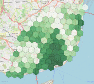
The “AI Green Index”, supported by “Vouchers para Startups (Novos Produtos Verdes e Digitais)” focuses on understanding the environmental attributes of specific locations, answering “Which areas are greener?” and “Which areas support the population in having ecologic behaviors?”.
We collected thousands of images to recognize and classify environmental features such as sidewalk quality, proximity to bike-sharing stations, and nearby green spaces. This index combines these image-based findings with open geospatial data, like local commerce and service types, to provide a comprehensive view. You can use our AI Green index here.
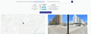
With “AI City Index“, users can ask questions about an address (e.g. “Does this address have sidewalks?”) and obtain an AI-driven response that uses open-source data from Google Street Maps. This demonstrates the flexibility of our models to answer complex questions about locations.
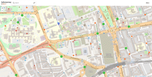
In Lisbon, as part of the VoxPop project, we adapted our platform to create a wheelchair accessibility index that identifies common obstacles like narrow sidewalks, lack of ramps, and service accessibility challenges, helping improve inclusivity in urban planning.
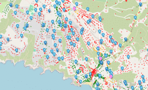
In collaboration with Algar as part of the ReSource program, we are applying our smart index approach to enhance the coverage and efficiency of recycling services. By using AI to identify obstacles for recycling trucks—such as narrow streets or low-hanging wires—we’re helping to maximize waste collection and improve household service coverage.
In our pilot project in Lagoa, Algarve, our AI achieved a 70% alignment with human assessments. At this point, we’re calculating the impact on the business by measuring acceptance rates and time saved per new recycling bin proposal. This impactful application of our smart city index has even earned us the Data Changemaker of the Year award from the Data Science Portuguese Association (DSPA) and NOVA SBE!
If you’re interested in exploring how our smart indexes can answer questions about your city’s “green score” or other urban insights, book a demo call with us today. With access to real-time, data-driven insights, you can make informed decisions that align with sustainability goals, enhance accessibility, and drive smarter urban planning.
Whether you’re a city planner, business owner, or environmental advocate, our tools offer a powerful way to transform complex data into actionable intelligence tailored to your needs. Join us in redefining how we understand and shape our urban environments—one data point at a time.

Like this story?
Special offers, latest news and quality content in your inbox.
Feb 10, 2026 in Listicle: Examples
Discover digital business transformation examples and how AI, data, and strategy fuel growth with practical, actionable insights.
Feb 6, 2026 in Resources
Discover the 12 best AI tools for small business success. Our guide covers strategic insights, pros & cons, and how to choose the right AI partner.
Feb 3, 2026 in Guide: How-to
Master customer retention rate calculation with this practical guide. Learn the formulas, see real-world examples, and get actionable tips for business growth.
| Cookie | Duration | Description |
|---|---|---|
| cookielawinfo-checkbox-analytics | 11 months | This cookie is set by GDPR Cookie Consent plugin. The cookie is used to store the user consent for the cookies in the category "Analytics". |
| cookielawinfo-checkbox-functional | 11 months | The cookie is set by GDPR cookie consent to record the user consent for the cookies in the category "Functional". |
| cookielawinfo-checkbox-necessary | 11 months | This cookie is set by GDPR Cookie Consent plugin. The cookies is used to store the user consent for the cookies in the category "Necessary". |
| cookielawinfo-checkbox-others | 11 months | This cookie is set by GDPR Cookie Consent plugin. The cookie is used to store the user consent for the cookies in the category "Other. |
| cookielawinfo-checkbox-performance | 11 months | This cookie is set by GDPR Cookie Consent plugin. The cookie is used to store the user consent for the cookies in the category "Performance". |
| viewed_cookie_policy | 11 months | The cookie is set by the GDPR Cookie Consent plugin and is used to store whether or not user has consented to the use of cookies. It does not store any personal data. |